Let's Get in
Touch
Email Address
kareem@leronegroup.com
Call Us
+1 721 522 0546
Address
Walter Nisbeth Road #13
Call +1 721 522 0546
SVBP 2012 as the basis
Sint Maarten’s regulations are based on the Unified Comparable Zoning Designation Plans (SVBP 2012)used in the Netherlands. These plans set standards for the design and layout of zoning designations,including amendments and government zoning plans. The SVBP aims to create consistency and clarity across these plans. While Sint Maarten has adopted this methodology for its development plans,adjustments were made as needed to fit local conditions.
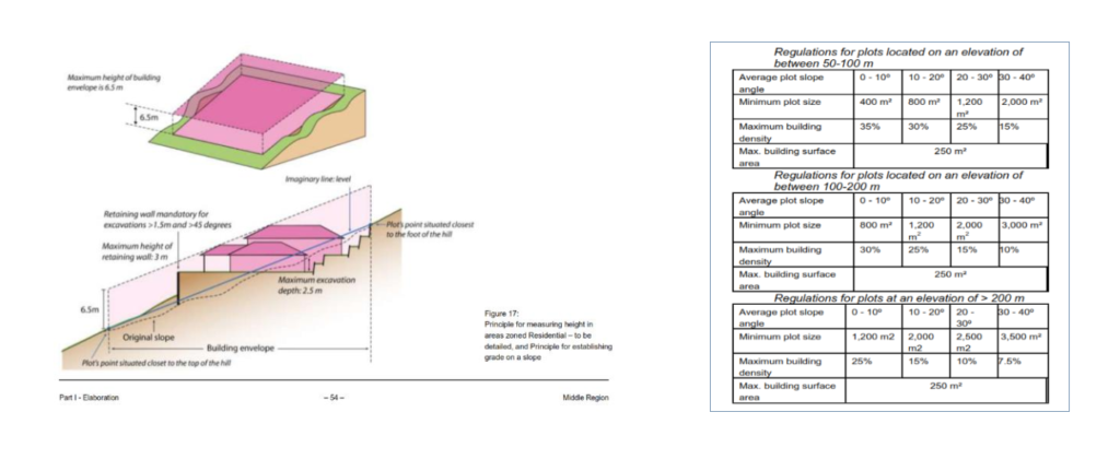
HILL SIDE POLICY
The hillside policy of Sint Maarten includes specific regulations for grade and slope, with the current area slope at about 45 degrees. The location is below 100 meters elevation, as per government requirements divided equally. The design of hillside houses, as illustrated in the accompanying picture, incorporates safety walls and features drainage systems to manage stormwater during heavy rains. In Sint Maarten,regulations dictate lower building density at greater elevations. In these zones, minimum lot sizes are specified, requiring larger plots as slopes become steeper. Additionally, the permitted building density decreases with elevation and slope angle. Specifically, a maximum of one building is allowed per lot, with a maximum surface area,
building height regulations differ based on slope and elevation. In lower-lying areas (Residential – 1),
land is relatively flat, whereas in ‘Residential – 2’ and ‘Residential – To be detailed,’ the terrain is more varied. To clarify maximum building height, a ‘building envelope’ is utilized. For example, parcels below the 50-meter elevation line can have a maximum height of 10 m, while those above are limited to 6.5 m.
This differentiation allows for taller buildings in flatter areas without disrupting the landscape significantly.
The choice between applying an immediate final zone (R-2) or a zone requiring further detailing depends on the desired level of control over land subdivision. Reasons for seeking more control through detailed planning include:
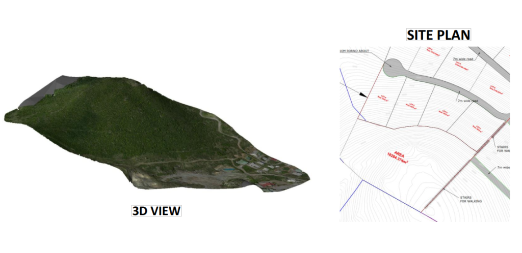
SITE INFORMATION AREA
NO. OF PROPOSED LOTS 4
DATUM LEVEL UTM, WGS-84
COORDINATE SYSTEM UTM84-20N
Site Analysis: Detailed mapping of slopes and elevations. Identification of soil characteristics that affect drainage and absorption. Assessment of native plants and ground cover that can impact water flow
Runoff Calculations: Estimate the volume and rate of stormwater runoff based on rainfall data and site characteristics. Mapping natural drainage patterns and identifying potential problem areas.
Erosion Control Measures: Installation of silt fences to capture sediment during construction. Encourage ground cover to stabilize soil and reduce erosion.
Regular Inspections: Schedule for inspecting and maintaining BMPs to ensure functionality. Guidelines for maintaining plant health and preventing invasive species.
Local Regulations: Ensure that the plan meets local stormwater management regulations and environmental guidelines. Identify any necessary permits required for implementation,
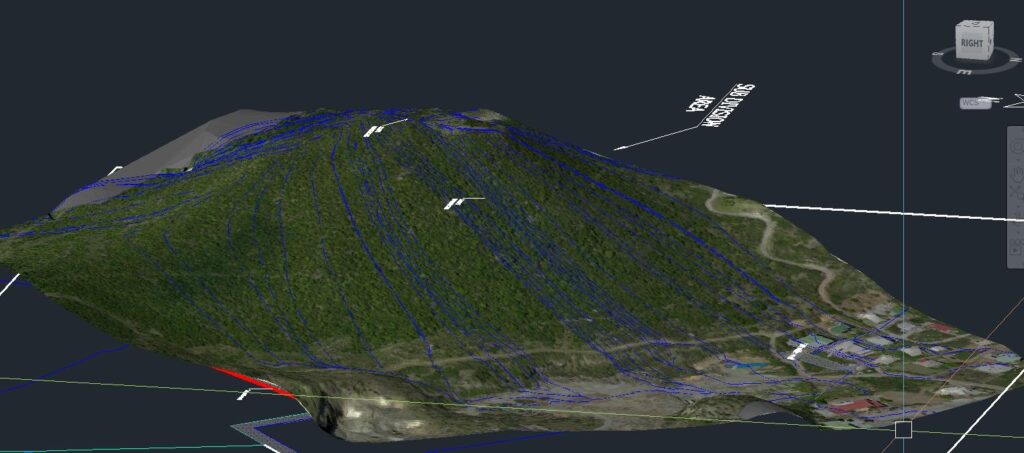
The existing stormwater plan indicates that flow rates in the steep areas are double compared to the planned areas, it’s important to address this discrepancy to prevent erosion, flooding, and other related issues
kareem@leronegroup.com
+1 721 522 0546
Walter Nisbeth Road #13